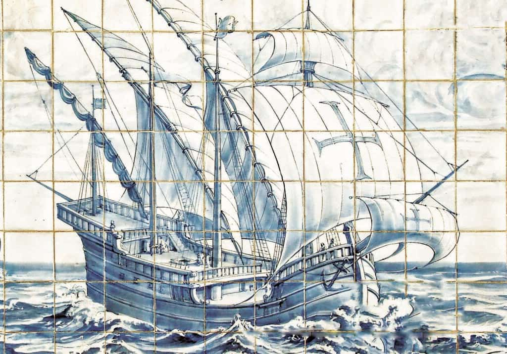
Purpose-built for traversing the oceans, the wide-hulled caravel (caravela in Portuguese) was arguably Portugal’s most significant contribution to maritime history and an integral part of Prince Henry the Navigator’s ambitious plan for extensive sea exploration in the 15th century.
Widely used in the late Middle Ages, this elegant-looking vessel measured around 25 metres in length and comprised two or three masts, with later versions having a fourth added with square rigging for running before the wind. It was built of flush-fitted planks attached to a previously-assembled frame, often with a double tower at the stern and a single tower in the bow.
The success of this vessel enabled the Portuguese to be the first Europeans to cross the equator, round the Cape of Good Hope and get to India by sea. It also enabled them to reach South America, land in Australia 200 years before Captain Cook and be the first to trade with China and Japan. On top of that, two of the three ships under the command of Christopher Columbus on his famous voyage in 1492 – Niña and Pinta – were both caravels.
Adapted from Arab vessels, the caravel was fitted with a special type of rigging so that the sails received wind on either side, keeping the same edge forward unlike square-riggers. Its triangular sails were set on long yards which sloped down from well above the mast to almost deck level.
Lightness and speed were two of the caravel’s strong points, but outstanding was its capacity for sailing to windward. It was this capacity, unique in its day, which enabled the Portuguese to sail beyond all known limits and return to tell of their experiences.
The earliest caravels were built in the docks of Lagos in the western Algarve, from whence they were initially put to sea, with Prince Henry’s first objective to reach Guinea where gold was mined, after which he intended to tame the Atlantic and circumnavigate Africa in an effort to reach India.
The Portuguese Discoveries
The prospects of these intrepid voyages compelled Henry and his contemporaries to create a brand new ship which revolutionised navigation, and the design of the caravel was far superior to any of the existing sailing ships of that time, and far more seaworthy.
He designed and perfected his ground-breaking vessel at nearby Sagres where he established his pioneering School of Navigation, plotting the routes with charts, maps and sea manuals together with an impressive assortment of cartographers, experienced mariners, astronomers, wealthy traders and mathematicians, who willingly shared their knowledge and ideas in the interest of exploration.
At the beginning of the 15th century, the known southern limit of the Atlantic Ocean was Cape Bojador, a headland in north-west Africa. Its name in Arabic was Abu Khatar (Father of Danger) and the disappearance of numerous European vessels attempting to round the cape spawned horror stories of seething serpents and other frightening sea monsters.
Nevertheless, in 1434 the Lagos-born sea captain Gil Eanes rounded the cape in a barquentine-caravel and the stage was set for a new era of seafaring adventures, with Portugal at the forefront of world exploration.
The port of Belém (indicated on the Google map below) in west Lisbon eventually replaced Lagos as the main point of both departure and return for many of the long-distance voyages during Portugal’s golden Age of Discovery, and it was from here that Vasco da Gama departed with a fleet of caravels in 1497 to successfully round the Cape of Good Hope, becoming the first European to discover a sea route to India in the process.
Need more sightseeing ideas for your next visit? Listen to the Portugal Travel Show, the podcast for people planning a trip to sunny Portugal…


